It was cold starting out, but we all knew it was going to warm up, so we dressed in removable layers. I was worried because I only had about 3 hours of sleep before the ride--was I ready? Could I really do the hills and the mountain? 93 miles?
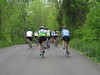
We started out, going down hills, climbing, cresting, turning...most of us were taking it easy. Even the Maniacal Kelly was taking it easy. I actually got to ride with Mike for a little bit, which was nice because I hadn't ridden with him all season. Got to comingle with some of the other riders I hadn't really had a chance to talk with before.
It was all fine-and-dandy until we turned onto Snickersville Road--that's where the real climbing began, especially up to Rte.7. Ugh! Maniacal Kelly was even saying that he wasn't going to do the Naked Mountain loop because the climb was hard for him, too. But we made it to the top, to Rte.7, and rode up to Blueridge Mountain Road.
Now Kelly had a good point (and of course, since he was the one who made the cuesheet): any time you see a "Mountain" or "Manor" in the street name, it'll be on a mountain. Blueridge Mountain Road, which ascends Mt. Weather, was one such road. It was steep, and I mean steep--it was so steep that I was in the granny gear the whole way up, glancing up at nearby landmarks and then pedalling to reach each one: That signpost, that tree, that mailbox. Up and up and up and up, we climbed, reaching the top of Mt. Weather.
There was an excellent payoff for the climb: the descent, and the SAG stop at the bottom. Awesome!
Everybody gathered there--instead of the usual 5-minute stay, we all stayed for 15 minutes, watering-up and eating. Then Chuck and I headed out, along Rte.50 with some nice, flat terrain (and an awesome bomb down the road in the beginning). Curiously, we encountered a lot of other riders from the local Multiple Sclerosis ride, and we all shared the same route for about 20 miles to the next SAG stop.
The next SAG stop was easy to miss, and many of us DID miss it. But it was nice--there was lunch and drinks and bathrooms; the whole works. Wisely, we all stayed away from the brownies and cookies, which, while good, would simply sit in our stomaches and make riding that much harder. Again, it was another 15-20 minute stay. Good thing we're all in good-enough shape that such a long stay doesn't affect us too much anymore, and we all know not to hammer it out of a SAG stop, to ride easy for a few miles to get our legs back into it before really laying down the power.
I headed out alone--Kelly was waiting for his group, and he sent me ahead with his blessings to catch up with Josh and Noel, who had left not two minutes earlier. I caught up, instead, with Robert and Jordan, who both missed the 2nd SAG stop, passed them, and caught up with Josh and Noel, who had stopped to rest with two others who also missed the 2nd SAG stop. We pressed on, climbing and bombing and climbing and bombing, all the way out to The Plains, VA, where Josh blew his front tire (again!), and we stopped...not one turn away from the 3rd SAG stop (which, ironically, was also easy to miss).
At the 3rd SAG stop, we stopped to get water and food...and to gaze, slack-jawed, at B-2 Stealth Bomber, flying over head as it made an appearance at the nearby airshow. Holy cow! I never thought I'd see one in person!
We headed out once more, making it all the way to the 2nd Big Climb (Mt. Weather was the First), when we discovered that "SL" on the cue-sheet meant "Sharp Left" (not slight left), and that the road we were supposed to be climbing was all gravel and dirt, perfect for ruining a good set of tires. We found an alternate route and headed back home. It was much flatter, with smaller climbs that all of us could now manage with ease.
This time it was Jordan and me, finishing together and meeting up with those who had been warned ahead of time that the 2nd Big Climb was out and who finished earlier.
Afterwards, we stayed around for the cookout and celebration, thrown by Rob and Ruma. Good times! Good food!
Statistics:
Bike: Trek 1500
Distance: 91.80mi
Saddle Time: 6h01m36s
Actual Time: 7h
Start Time: 7:30AM
End Time: 2:30PM
Start Outside Temp: low-mid 50's
End Outside Temp: high 70's
Max Speed: 40.0mph
Avg Speed (saddle): 15.2mph
Avg Speed (actual): 13.1mph
We're all ready for Tahoe, to ride, to save lives, to honor those who aren't able to ride with us physically.
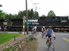
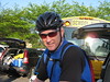
I also had my new Canon SD1100 camera, and I was snapping pictures like crazy (the fast micro-SD card makes this easy!), both at the stops and on the road. So far, I'm quite happy with the thing--here are a few choice photos; the full set is at: http://www.flickr.com/photos/kent_le/sets/72157605115520193/


No comments:
Post a Comment